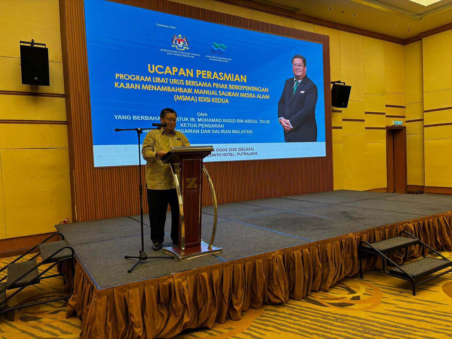
Image Source: Jabatan Pengairan dan Saliran Malaysia – JPS Facebook
On 18 August 2026, the Department of Irrigation and Drainage (JPS) convened the Program Libat Urus Bersama Pihak Berkepentingan at Hotel Zenith, Putrajaya, to present the draft of the revised Manual Saliran Mesra Alam. ACEM was represented at the session and has since submitted comments to JPS.
The revision succeeds the 2nd Edition of 2012, which has governed drainage submissions for fourteen years. The draft runs to three parts and roughly 1,500 pages against MSMA2’s 807, and it changes not only the numbers engineers design to but the kind of analysis a submission is expected to contain. This briefing sets out what is coming, what it will mean in practice, and the position ACEM has taken.
The draft is not yet in public circulation and remains subject to revision. What follows is based on the material JPS presented at the engagement session.
Why a new edition
JPS framed the revision around four drivers: continued urbanisation; more frequent flooding attributed to prolonged rainfall, storm bursts and king tides; persistent water quality problems in receiving waters; and the need to align stormwater practice with the National Water Policy, Water Sector Transformation 2040, and the IRBM, PISMA, ISMP and NAWABS programmes.
The lineage is worth recalling. The 1975 Urban Drainage Design Manual was a peak-discharge document; get the water away. The first MSMA introduced best management practices; MSMA2 moved the emphasis to control at source. The new edition extends that logic outward again, to the catchment, to the receiving water, and to sectors MSMA has never previously addressed.
The headline change: MSMA is no longer an urban drainage manual
The single largest structural change is scope. The new manual runs to eleven chapters, of which Chapter 11, consist of 483 pages on its own, is entirely new and covers nine development sectors that the 2012 edition did not touch.
| Chapter | Subject | Status against MSMA2 |
| 1 | Introduction | Expanded: catchment processes, history, national policy linkage |
| 2 | Authority Requirements and Design Acceptance Criteria | Substantially rewritten: the chapter ACEM members will feel the most impact |
| 3 | Rainfall Runoff Estimation | Expanded: low-ARI rainfall, wider method set, model validation, sequential storms |
| 4 | Stormwater Hydraulic Design Fundamentals | Reinstated: absent from MSMA2, now front-loaded |
| 5 | Stormwater Quantity Control Structures | Consolidated: OSD, ponds, culverts, gates, pumps in one chapter |
| 6 | Stormwater Conveyance | Expanded: energy losses, backwater analysis, stepped channels |
| 7 | Stormwater Quality and Treatment Control | Updated: local EMC data, revised treatment objectives |
| 8 | Property and Building Drainage | Expanded: flat roofs, siphonic systems, rainwater harvesting |
| 9 | Nature-Based Stormwater Solutions | New chapter: green roofs, bioretention, WQ ponds, wetlands |
| 10 | Erosion and Sediment Control | Substantially rebuilt: new erosivity mapping, expanded BMP suite |
| 11 | Specific Land Developments | Entirely new: linear, mining, quarry, agriculture, logging, coastal, highland, lowland, solar farm |
Table 1 — Chapter structure of the new MSMA
Five changes that will be felt at the drawing board
1. Levels of Analysis
Developments are to be classified as Level 1, 2 or 3, and the classification determines the analysis method. This is a new concept, where the phrase does not appear in the current MSMA2 and it is the single largest driver of effort in the draft.
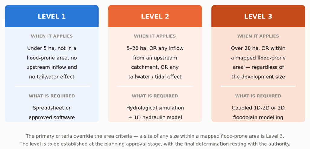
Figure 1 — The three levels of analysis and what each requires.
Two features matter commercially. Any tailwater or tidal influence will require Level 2 as a minimum, which captures effectively every coastal, estuarine, lowland and riverside site. And a site of any size within a mapped flood-prone area is Level 3. So, an infill lot in a flood-prone town may require a coupled 1D-2D model.
2. Higher design storms
Minimum design ARIs rise across the board. The minor-system standard doubles for commercial, industrial and institutional development, quadruples for infrastructure and utility, and rises five-fold for sport fields, parks and agricultural land.
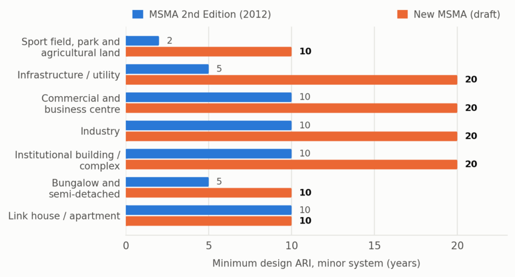
Figure 2 —Minimum design ARI for the minor system, MSMA2 against the new draft.
A climate change allowance will be applied, subject to updated NAHRIM’s publications. Taken together with the ARI increases, design flows for a commercial minor system rise materially over MSMA2, with potential corresponding effects on drain sizes, pond volumes and land take.
3. Total Maximum Conveyance Capacity (TMCC)
Major drainage systems are to be assessed against the maximum discharge the receiving system can deliver, taking into account upstream land use change and future development, with drainage corridors reserved on that basis. Where no approved land use plan exists for the upstream catchment, it is to be assumed developed. In practice this means two hydrological assessments for every major drain; one to size the corridor, one to size the section.
4. Sequential storms
Storage facilities are to be verified against a pair of consecutive storms, not only a single critical storm. Routing through a detention system commonly takes longer than the design storm, so a second storm can arrive before the pond has recovered. The evidence JPS offered was compelling.
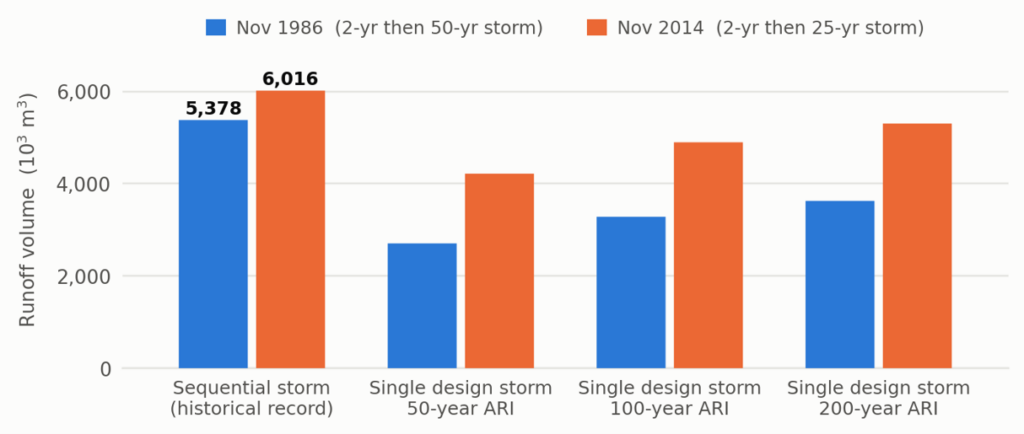
Figure 3 — Recorded consecutive-storm events against single design storms. Source: JPS, 18 August 2026.
In both recorded events, a modest storm followed by a larger one produced more runoff volume than a single 200-year design storm. For designers this means a larger design-storm matrix and, in most cases, a larger pond.
5. More rigorous hydraulic checking
Drainage design moves beyond capacity-based sizing. Friction, junction, bend and exit losses are to be explicitly quantified; the hydraulic grade line checked; backwater analysis incorporated; a Froude number criterion applied to control flow regime; and blockage factors applied to inlets and culverts. Culverts and bridges are to be sized from a computed water surface profile over an adequate reach rather than from a nomograph.
What this means for practice
The changes are technically defensible. The practical difficulty is that they move a substantial body of routine drainage work out of the reach of the engineer who currently does it, and into the hands of a specialist modeller.
| Change | What it requires | Where the difficulty lies |
| Levels of Analysis | 1D network modelling at Level 2; coupled 1D-2D floodplain modelling at Level 3 | Modelling capability is not widely held in the profession. Level 3 also needs a licensed 2D package and a competent modeller. |
| Higher design storms and flow control | Larger drains, larger ponds, more land reserved for detention | Land take on constrained sites; viability of marginal schemes. |
| Total Maximum Conveyance Capacity | Catchment-wide land use build-out assessment for every major drain | GIS capability and liaison with planning authorities; adds weeks to a masterplan study. |
| Sequential storms | A materially larger design storm matrix and repeated pond routing | Existing spreadsheets need rebuilding; effort multiplies. |
| Tailwater and tidal boundaries | Time-varying boundaries; tidal analysis; in some cases field tidal measurement | Specialist coastal capability sits with a small number of firms nationally. |
| Terrain and data | LiDAR-grade terrain data for detailed design and 2D modelling | Not a public dataset. A new acquisition cost and a lead time on most projects. |
| Chapter 11 sectors | Sector-specific analyses for mining, coastal, highland, peat and others | Several require expertise no ordinary civil consultancy holds in-house, such as geotechnical, coastal, geochemical, ecological. |
Table 2 — The main changes and their practical consequences for consulting practice.
ACEM’s submission supports the direction of the revision. Restoring hydraulic fundamentals, bringing climate change into the design framework, and filling the sectoral gaps are all overdue. The submission concentrates on three things: that the manual should be capable of being applied consistently, that the profession should be given time to acquire the capability it now assumes, and that the transition should not impose rework on projects already approved and under construction.
On the first, ACEM has lodged a detailed comment register with JPS, seeking a single value where the draft currently gives several for the same quantity, acceptance thresholds where a criterion is imposed without one, and clarity on the allocation of responsibility between the designer, the contractor and the operator or asset owner. Those are drafting matters, and they are best resolved before publication rather than through years of case-by-case interpretation at counter level.
The two requests of most direct consequence to members are set out below.
ACEM’s two principal requests to JPS
- A defined grace period before full enforcement. ACEM has asked that a transition period be provided between gazettement and full enforcement of the new manual, with a published commencement date. The purpose is to allow the profession to train and upskill, particularly on the modelling requirements, since capability in 1D network and coupled 1D-2D floodplain modelling is not widely held across the industry. ACEM has offered to work with JPS, and with IEM and BEM, on a structured capability programme during that period.
- No retrospective application to approved schemes. ACEM has asked that projects with plans already approved on the basis of MSMA2 requirements not be required to be revised to suit the new criteria. Revision at this stage would mean substantial rework, and much of it would fall on areas that are already constructed or under construction, platform levels, drain alignments, pond locations and pond sizes are fixed by approved layouts and by works already in the ground. ACEM’s position is that a designer who complied with the manual in force at the time of design should be taken to have discharged their duty.
Both requests are, in ACEM’s view, matters of orderly implementation rather than opposition to the technical content. A manual that takes effect before the capability to apply it exists will be applied poorly; and one applied retrospectively to schemes already in the ground imposes cost without delivering the benefit the new criteria are intended to achieve.
Members with questions on the revision, or who wish to contribute to ACEM’s continuing engagement with JPS, are invited to contact the Secretariat.